Gunung Machinchang
Experience Details
- 💸 Price Free
- 📌 Location Malaysia, Langkawi Islands
- 🕝 Duration 4 hours
- 🎒 What to bring Swim suit, snacks, 2/3L water pp
Mount Machinchang is the second highest peak on Langkawi island. To achieve the beautiful view at the top you can decide between taking the cable car or climbing. We chose the second option …
If you are planning to hike to the top of Gunung Machinchang there are a few things to be aware of. First, this is a tough climb, like us, you might look at the height and think “ahh 700 meters, that isn’t too bad” but you should know that this is 700 meters of steep incline so be prepared and don’t climb when there is due to be rain.
Where To Park And How To Get There?
As with most places on Langkawi island the best way to get there is by renting a scooter or car. We decided to park our scooter at the Oriental Village for free and walk an extra 15 minutes to the car park with an entrance fee. After a tough 4 hours of hiking we were not excited to walk an extra 15 minutes along the road. Our advice is to pay the small entrance fee at Telaga Tujuh Waterfall - Parking and save yourself the bother!
Oriental Village
Having said that, maybe you want to check out the Oriental Village anyway. This is the starting point for the Cable Car and there are some nice looking cafes and restaurants.
Up The Staircase From Telaga Tujuh
Nothing like walking up a never ending staircase to get you in the mood to climb a steep mountain, right? The first part of the trek is a staircase from Telaga Tujuh Waterfall car park to the natural pools and by the time we reached these we were already sweating.
On the far side of the natural pools you can find the start of the trail to the top of Gunung Machinchang. We weren’t sure straight away that this was the path so for reference, it looks like this:
The First Hour
The first part of the trek is nice. It’s steep but not too steep and it is a pleasant walk through the jungle which is one of the reasons we chose this mountain instead of the tallest mountain in Langkawi, Gunung Raya.
For some reason someone thought it was a good idea to create signs which count down the meters to the halfway point of the trek (U-Turn Point). So many people, including us, reach this point thinking it is the top, actually you’ve still got an hour to go!
Getting Steeper (U-Turn Point)
A lot of people we met turned back at this point. Usually, because they had thought this was the top of the mountain. By the time you get here the path starts to get really steep with a lot of rope work. We were questioning whether to turn back as our legs were burning but we managed to find the motivation to keep going. “Do it for the blog!”
To The Peak
The challenge begins. Initially, you are fooled by a brief downslope but this doesn’t last for long. This part of the climb was very steep and rocky and required a lot of rope work. So, be ready for a challenge.
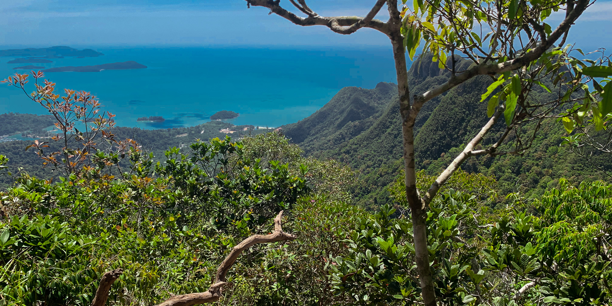
Lookout No.1
Two hours from the Oriental Village and about 50 minutes from the U-Turn Point we reached the first lookout. At this point, the hard work starts to feel worth the effort. The view of the neighboring humped mountains and cable cars is amazing. At this point, we thought we had reached the top but not yet.
The Peak
Ten minutes later, we had reached the peak and were met by a well-deserved cool breeze. At the top, there is a beautiful 360 degree view. We had perfect visibility and an amazing clear day. We stayed up here for a while all by ourselves and enjoyed a protein bar whilst taking in the view.
To The Natural Pools
We were actually a bit slower on the way down taking our time to climb down the rocks. After two hours, we reached the natural pools. What better way to finish 4 hours of hard work than to chuck yourself down a natural water slide into some refreshing clear water.
Closing Thoughts
Gunung Machinchang is a tough climb and Matthews calves were burning for the next few days. For those up to the challenge, there is an amazing view and sense of achievement in it when you reach the top. Whilst you can kind of buy this view by taking the cable cars up to the walkway, we were happy to reach an even higher peak and instead of being surrounded by people, have the view all to ourselves.